View from the CZBB control tower
Posted by Jim DeLaHunt on 29 Jan 2012 at 08:43 pm | Tagged as: aviation, British Columbia, Canada
 CZBB, Boundary Bay airport, is my home field. I rent aircraft from Pacific Flying Club there. And the friendly air traffic controllers in the CZBB control tower are my rock and my safety. Saturday, I was at the airport with some spare time, and lousy weather made it a quiet day on the airfield. So I drove over to the tower for a brief visit. I had a great chat and got some nice pictures.
I think it’s great for pilots to visit towers and ATC sites, and for controllers to fly along with pilots. During my primary flight training, my instructor, Raeleen Ranger, made a point of getting me up into the tower at CYPK, Pitt Meadows Airport. It was interesting to see their gear, and invaluable to put a human face on the voices who tolerated my bumbling in, and on, the air. I admire the patience and supportiveness of the controllers at training airports, like Pitt Meadows and Boundary Bay, who give novice pilots a safe place to learn and make mistakes. I was particularly touched when, after I flew my first solo, a CYPK controller was one of the people who came down to congratulate me.
So how does one get to CZBB’s control tower? There’s an emergency number listed in the CFS, the directory of Canadian airports, but I didn’t want to startle that line with a routine request to visit. The club dispatcher dug up a number, 604-946-0710, which turned out to be voice mail for a Nav Canada person, probably the tower manager. It was Saturday, not surprising they were out. So I followed my nose: drove down 72nd Street, in the obvious way implied by the Boundary Bay airport diagram in the CFS. Keeping my eye on the tower, the correct left turn was obvious. A gate blocked the driveway, but there was an intercom placed conveniently in front of the gate, for use by approaching car drivers. Hi, I’m a pilot with Pacific Flying Club, is this a convenient time for a tower visit, I asked. Sure, if you don’t stay too long, was the reply. And in I went.
The controller on duty was quite welcoming. He entertained my questions, interspersed with more traffic activity than I had expected on such a cloudy and wet day. He let me take pictures of the gear and the view, though he ducked out of the shots himself. A second controller, who showed up a few minutes later, and a visiting ex-controller who now flew airliners, were equally friendly.
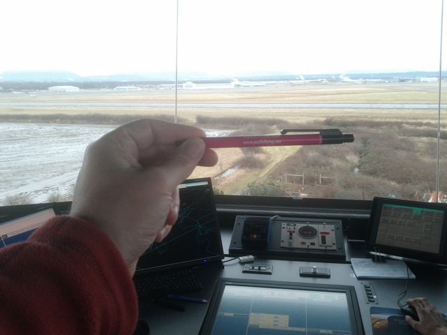
 So what does it look like? On the left you can see the air traffic controller’s station. The screen on the left, and the screen flush with the desktop, show a “strip†for each aircraft approaching, in, or departing from CZBB’s airspace. These are touch-screens, so the controller can move a strip from one section to another with the swipe of a fingertip. And there is yet another screen out of the shot to the right with strips.
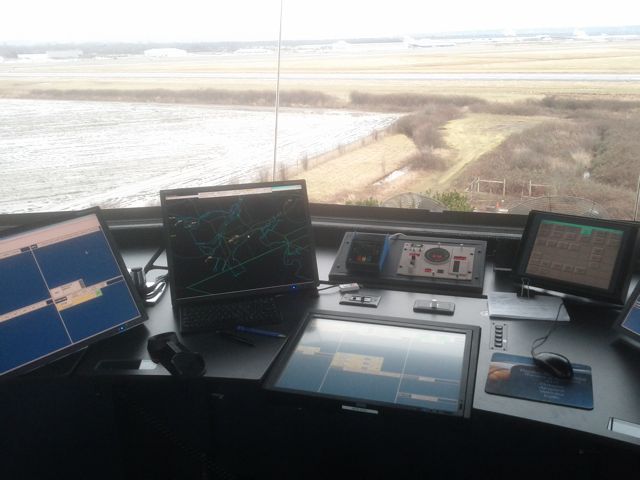
The dark display with the lines is a radar view of the regional airspace (better view below). The knobs and dials on the far side of the centre desk show weather information such as wind and air pressure. The small screen on the right operates the computer system. The gear and the furniture was very high-tech and new; apparently the whole tower had just been remodeled.
Runway 12-30 is the grey concrete linear object, running left-right (just above the pen, in the photo above). Pacific Flying Club is the single-story white building ( just above the top knuckle of the hand holding the pen, in the photo above). Other Boundary Bay hangars and buildings are to the left and right of the club. Runway 07-25 runs left and right in front of the hangars, but it’s hard to see. If you look closely at the upper-left part the photo above, you can see a Cessna 172 doing a touch-and-go on Runway 07 heading from left to right.
 The view of the airport was astonishingly clear. Either the tilted glass does more for visibility than I realised, or they have some bad-ass anti-glare filters on the windows. There were glare-blocking shades which the controller could raise and lower at the press of the button.
The monitor with the radar view was quite interesting. On the right you can see a radar view of the Lower Mainland airspace, including CZBB (Boundary Bay airport, just above the pen tip), CYVR (Vancouver International Airport, above the hand), and CYNJ (Langley Regional Airport, the centre of the circle cut off by the right side of the display). CZBB’s two V-angled runways are visible just above the pen and to the left of the white arrow pointer. The yellow dots with lines just above the CZBB runways are two aircraft on downwind for runway 07. You can also see a couple of aircraft at CYVR.
And I should confess the hidden agenda for the pen in these photos. Pacific Flying Club’s ubiquitous pens nest under the pilot seat of the club aircraft and hatch in the map pockets. The club’s general aviation group has a “PFC Travelling Pen” campaign, to take the pens across the planet, and take pictures of them against exotic backdrops. I can’t imagine no-one has photographed a PFC pen in CZBB tower, but I haven’t seen it yet. Maybe I’m the first.